 |
|
HOME | The Pilots | The
Plane | Pre-Flight | Itinerary | Latest | Flight
Following
| Discussion | Newsletter | Email
![]() Join
the Ponceby Newsletter Email list for
news about the next flight
Join
the Ponceby Newsletter Email list for
news about the next flight
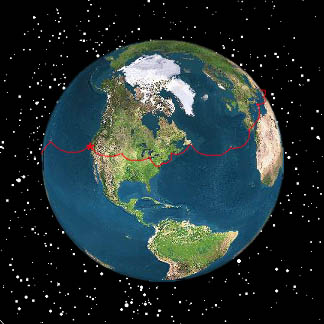
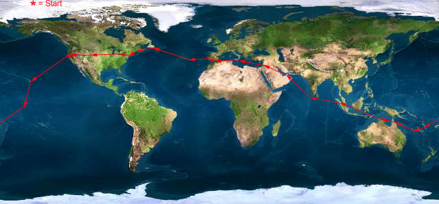
Kiribati to Western Samoa Hawaii to Kiribati California to Hawaii
 |
 |
 |
 Live Satelite Image Live Satelite Image |
Satellite data provided by The Living Earth ® Inc./Earth Imaging © 1996, All Rights Reserved. | |
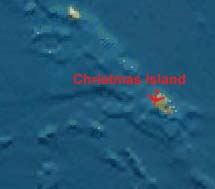
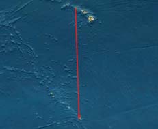
Leg 2: PHNL-PLCH, Honolulu to Christmas Island, Kiribati, 23 July 98, 6.3 hours
Lots of delays getting out of Honolulu. Our portable printer power supply had died, so we had to make an emergency run to CompUSA to get a new one, which actually required buying a whole new portable printer (Canon BCJ-80). And since Canon stupidly provides an AC adapter that only works in the US (120v, 60Hz), we also had to get a battery supply that could be charged off the airplane’s power with 120v inverter.
Then we found out belatedly that one must file an outbound customs General Declaration (GenDec) when leaving Hawaii—the only state in the entire US that requires this for international flights. Our handlers, Air Services Hawaii, was able to take care of that for us, but the paperwork processing took about an hour. Combined with the always-slow fueling when having to put fuel in the cabin ferry tanks, we took off about two hours later than planned.
This was a relatively short leg, only about 1200nm, but with no land en-route to our destination, we wanted ample fuel reserves. We filled the main and aux tanks (474 gallons, 3176 pounds), and also put 60 gallons in each of ferry tanks #1 and #2, for 594 gallons fuel. This gave us about a three-hour reserve.
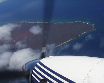
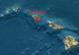
"Touring the Hawaiian Islands before continuing on to Kiribati."
We filed a flight plan to start VFR out of Honolulu to do some sightseeing before heading south to Christmas Island, picking up our IFR clearance over Kona VOR. This sort of flight plan always seems to confuse ATC, so we had to re-explain our intentions to each new controller. The weather was great, with scattered cumulus clouds over the islands, and severe clear elsewhere. Beautiful sights.
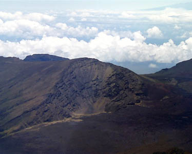
"Craters of the moon (I think) on Maui."
Shortly after crossing Kona, we picked up our IFR, climbed to our assigned cruising altitude of FL180 (18,000 feet), even though our course (174 degrees) should have required an odd flight level, like the FL190 we had filed. Honolulu Center rapidly handed us off to ARINC San Francisco Radio on the HF, and we had excellent reception and transmission on our primary frequency of 8867 MHz.
The weather was fine, and as we moved south we got a striking visual of the ITCZ (Inter-Tropical Convergence Zone), which was located today at about 10 degrees north. Several large cumulus buildups, but little storm activity. The Stormscope showed no lightning activity at all, but the weather radar showed some Level 2 precipitation, which we were able to deviate around. The ITCZ was no more than 100 miles wide, so we were through it quickly, with little turbulence, and the rest of the leg was filled with scattered cumulus, making beautiful shadows on the water.
While the HF coverage was excellent, the same frequency was used by Tahiti Control, and so was extremely crowded with lots of local flights jabbering away in French, making it very difficult for San Francisco Radio to communicate with its oceanic traffic.
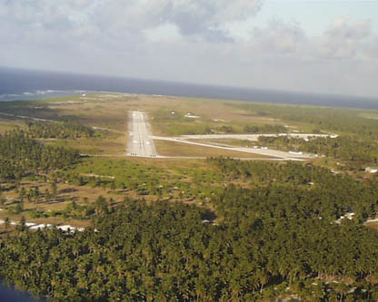
"On approach to Christmas Island."
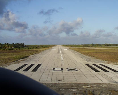
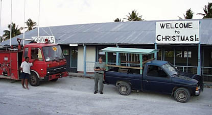
"Touching down on Runway 8 at Christmas Island, Kiribati."
While there is usually no one and nothing going on at Christmas, we kept hearing another flight also headed to Christmas Island with an estimated arrival time within minutes of ours. Turned out they were a Twin Otter out of Pago Pago (American Samoa), and we met up with them at the airport, road together in the back of a pickup truck to the Captain Cook Hotel, the only hotel on the island, and later had dinner together.
"Our customs official and ride to the Captain Cook Hotel at Christmas Island."
The drive to the hotel, squatting with our bags in the back of the Customs inspector’s pickup truck, gave us a brief glimpse of local life. Lots of people, especially tons of children, playing in the street, and cooking dinner in their open-air (no walls) homes. The children were most excited to see us palagis (white people), and were all screaming hello and waving to us as we drove by. Children everywhere, some even wearing clothes. As one of the pilots said, there’s not much more to do here than make babies…
We had low expectations for the amenities on Christmas Island, and were not disappointed. It would be considered a dive by almost anyone’s standards, but it was a pleasant feeling for us as we finally had hit the Third World we had set out to see. Lots of locals playing ping-pong in the bar, and about a dozen American divers in the restaurant. They were shocked to see us new arrivals, saying, "How did you get here? There are no planes for several days!" Well, that’s one of the joys of private aircraft: we go where and when we please.
We had drinks (VB, or Victoria Bitter, beer from Australia, one of my favorites from much beer drinking in my checkered past in Australia), and then dinner, with Paul and Tom (?), the pilots of the TwOtter. They run a Part 121 (scheduled airline) operation in Pago Pago, and were ferrying the plane to Honolulu for a buyer from the mainland. They were tired from a nine-plus hour flight, in a plane with over 1,000 gallons of ferry fuel in the cabin, cruising at 8,500 feet at 140 knots true, while burning 600 pounds (almost 100 gallons) an hour. No pressurization, no CDs or other creature comforts. By contrast, we’ll make the same flight in the opposite direction tomorrow in about six hours at FL190, burning only two-thirds as much fuel per hour at about 210 knots true. Their plane has practically the same engine as ours, the -27 rated at 680shp, but the plane is designed for hauling heavy loads on short hops, and is much less aerodynamically efficient .
Tom has spent the past six years flying commercially in the Marshall Islands and now American Samoa, and is getting antsy to get out of the tropics and move back to his restored Victorian house in the western hills of Iowa. Paul, their director of flight operations, also seemed a bit tired of the tropics, and remembers fondly his former life in San Francisco, even though he hasn’t been back in 25 years! We compared notes on how the flying has changed in the Bay Area in that time. They had lots of good info and tips for us on places to fly and see in the southeast Pacific.
After dinner, we came back to the room, did our flight planning, got the new printer working, and faxed our flight plan off to Universal to file for our morning departure. We’ll take a walk on the beach before leaving in the morning, and then head off to Samoa, where we’ll spend a night at the infamous Aggie Grey’s Hotel. Still have no word on where we’ll be able to stay in Fiji, but hopefully will be able to sort that out tomorrow night. If no luck, maybe we’ll go to Tonga or someplace else instead.
But we’ve made it to the real Pacific, and will cross the equator early in our morning flight (we’re only 2 degrees north right now). And crossing the equator is always something special.
No Internet access here (there’s barely phone and fax service), so we won’t be able to post this until tomorrow in Samoa, by which time we should have another installment as well.
 |
Satellite data provided by The Living Earth ® Inc./Earth Imaging © 1996, All Rights Reserved.
Click near each end of the red arrows for progressive reports
Click the following
Legs for Progressive Reports
|
Current position of
Ponceby.
Satellite
data provided by The Living Earth
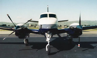
The E90 King Air "Ponceby" |
HOME | The Pilots | The Plane | Pre-Flight | Itinerary | Latest | Flight Following | Discussion | Newsletter | Email
Join the Ponceby Newsletter Email list for news about the next flight
Website Sponsored by
Webbnet - Internet Solutions