 |
|
HOME | The Pilots | The
Plane | Pre-Flight | Itinerary | Latest | Flight
Following
| Discussion | Newsletter | Email
![]() Join
the Ponceby Newsletter Email list for
news about the next flight
Join
the Ponceby Newsletter Email list for
news about the next flight
Darwin, Australia previous | next
Topics: John's Notes Leg 7 | John's Notes Leg 8 | Complete list of Destinations
Leg 7: YBCS-YPDN (Cairns to Darwin, Australia) 31 July 1998 4.6 hours
The vast and desolate Pacific gives way to the vast and desolate Australian continent. Australia is so sparsely settled that we must use the HF radio occasionally, even overland. In the outback, ATC is with Adelaide Center, over a thousand miles to the south. A light headwind gives way to strong tailwinds as we again approach the equator, from the south this time. We have carried a little ferry fuel, 400 liters only, in the event that the tailwinds don’t materialize. As usual, we land at Darwin with an extravagant reserve.
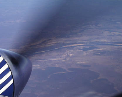
"awfully bleak terrain West of Cairns, Australia"
A few notes on navigation:
In general, we fly published routes wherever possible. There are several reasons for this. First, many countries, Egypt for example, only allow flight on airways. Overflight and landing permits for these nations may only be obtained after specifying your airway entry and exit points. Published routes give predetermined obstacle clearance altitudes and often allow good VHF communications. Finally, airways usually mean easier radio work. If we are traveling along J61 from Cairns to Darwin, it's much easier to report your position as "GULOP" intersection than to say "November 898WW was one five four nine south one four one five five east", the geographical coordinates of GULOP.
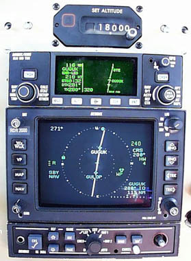
"enroute from GULOP to GUGUK, over Australia’s Cape York peninsula"
The photo above shows our normal navigation setup (apologies for the grainy picture, this is the best macro that we could get with the digital camera).
We enter the flight planned route into the KLN-90B (the box on top). The GC-360A graphics adapter (the box on the bottom) allows the waypoints of this route to be displayed on the radar display (the box in the middle). Here we are midway between GULOP and GUGUK, two waypoints along J61. GULOP is over the Cape York peninsula and GUGUK is over the Gulf of Carpentaria. The radar shows our heading to be 271 degrees vs. A course of 281 degrees. The ten degree crab angle is obvious from the tilt of the courseline. The wind direction is indicated by a green square on the left side of the display and the headwind component is shown in the text to the right as 4 knots. The radar itself is in a standby mode for clarity.
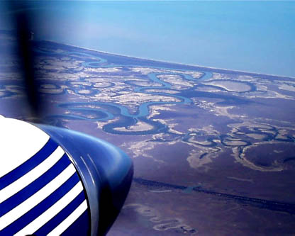
"enroute from GULOP to GUGUK, a view out the window"
Of course, all the information on the displays above is GPS based. We normally tune the associated VOR and NDB stations that define a route and display their output on the RMIs (which can NOT point to the GPS waypoints). However, our real backup is a second GPS built into the panel into which we input a duplicate flight plan and display its output on the copilots nav display. This way at each waypoint, we can compare the two displays to provide a check against (pilot) input errors.
As an aside, it’s interesting to note that many of the VOR and NDB stations along our routes are "on request only" (for a small fee of course).
Leg 8: YPDN-WSSL Darwin, Australia to Singapore Seletar 1 August 1998 8.5 hours
"Bali, Bali, This is November Eight Niner Eight Whiskey Whiskey position on one one, How Copy? "November Whiskey Whiskey, Bali I read you three, go ahead". Indonesian volcanoes glide by below. Lush Borneo passes to starboard as the Java gives way to the South China Sea. Now This is beginning to feel exotic.
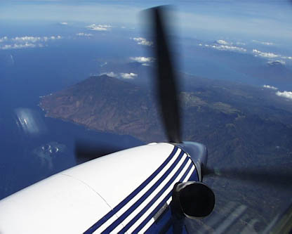
"First Sight of Indonesia, the disputed island of Timor"
Radio Woes:
We normally alternate seats with the right seater responsible for normal copilot altitude and airspeed calls, checklists, and communications. The left seater is responsible for flying. Doug flew right seat on this leg and it was a tough one. Maintaining contact with ATC was difficult, sometimes ten radio calls were made before a successful contact. Part of the problem is that often several ATC branches use the same HF frequencies, and unlike VHF where "stepping on someone" results in a loud squeal, you can generally hear all conversations at once. On this flight we could hear Perth Radio, Jakarta Control and Brunei information simultaneously on HF frequency 11356. Sometimes it just seemed that the controllers didn’t understand us well and didn’t want to talk. End result, several hours of the flight were spent fiddling with the radio.
Normal Fuel Management:
At 8.5 hours, this was the longest leg since the flight to Honolulu. We took off with over 5,000 pounds of fuel. The normal servicing drill is to check tire pressure, then to fill the mains, the aux tanks, and finally the ferry tanks in the cabin. In flight, we burn the mains down for an hour (to avoid the venting problem described in leg 1), then run the aux down to about 1/3 of their capacity. Then one of the three ferry tanks is selected to refill the aux tanks to about 2/3 capacity at which time the ferry tank is shut off. The aux are then allowed to burn down again to 1/3 capacity, and the refill process is repeated until the ferry tanks are empty. This usually requires 6 or 7 iterations before we are on wing fuel only.
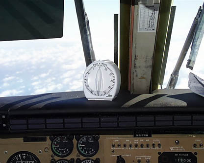
There is room for error here. Distractions abound in the cockpit, and if a careless pilot were to leave a ferry tank selected too long, the aux tanks would overfill and the excess fuel would be dumped overboard. Potential Catastrophe! We decided that an infallible means of avoiding the overfill was a necessary addition to the cockpit and settled on a common kitchen timer.
"the kitchen timer"
The transfer rate from ferry tanks to aux tanks is pretty uniform so we can time the refills. By setting the timer after each ferry tank selection, and placing the timer in plain sight on the dash, we’re always aware of the state of the transfer (another example of the superiority of analog displays). We have found that the chime of the timer will awaken even the most channelized pilot.
The timer has also proved useful as a reminder for ATC clearances, etc. A typical request would be to "Contact Brisbane information at 1310" which might be as much as an hour away. If you’re in the middle of a midday meal and Bob Marley, a gentle reminder is helpful.
The Flight:
We had originally planned to fly to Singapore’s main terminal of Changi. After learning that private aircraft normally go to the satellite airport of Seletar (also the location of a Hawker Pacific service center where we hoped to have a compressor wash accomplished), we filed for Seletar and launched. I am embarrassed to say that only in mid flight did we discover that Seletar had no instrument approaches. Hasty alternate plans were made to divert to Kuala Lumpur if the weather was low. Fortunately, the lowest cloud layer was over 2,000 feet so vectors for the visual worked fine.
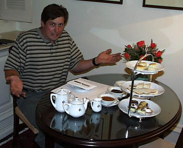
In Singapore, our rooms are at the old, British colonial hotel, Raffles. Here, the old yarn goes, a tiger was shot beneath the billiards table in the early part of the century.
"John at Raffles… bewildered by tea"
 |
Satellite data provided by The Living Earth ® Inc./Earth Imaging © 1996, All Rights Reserved.
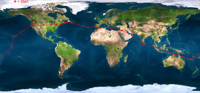
Click near each end of the red arrows for progressive reports
Click the following
Legs for Progressive Reports
|
Current position of
Ponceby.
Satellite
data provided by The Living Earth
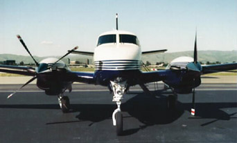
The E90 King Air "Ponceby" |
HOME | The Pilots | The Plane | Pre-Flight | Itinerary | Latest | Flight Following | Discussion | Newsletter | Email
Join the Ponceby Newsletter Email list for news about the next flight
Website Sponsored by
Webbnet - Internet Solutions